
I kept thinking to myself, "I did 70 miles of Texas hill country from Columbus to Luling in July, 2012. I should be able to do these 63 miles to Ocotillo."
I got up really early to finish packing and load my bicycle. I had to take more time than I intended to strap my "new" wine/water boxes to the back of my bicyle. It was a hard system to figure out, but I was ultimately satisfied with the results. Granted, I'm not all that excited about people thinking I'm carrying two boxes of Wine on my bicycle so I will probably "mask" the boxes in some way soon. Furthermore, I was not ready to carry that much water Up Hill if I could avoid it although, not too far down the road, I was kind of wishing I Had filled at least one of them!

I said "Good-bye!" to my host Jonathan and Konnor (who was waiting for his school bus) before heading up the road, pedaling very very slowly, most of the way, but managing to stay on the bike.

Every overhanging shade tree became a place to stop, catch my breath, and take a drink of water/electrolyte mix. It was very, very, slow going.
At one point I got somewhat confused by bike route signs that seemed to put me onto I-8 only to be contradicted by "Pedestrians, Bicyclists, [etc.] Prohibited" signs on the entrance ramps. So I had to turn around. Eventually, a local cyclist passed me and helped clear-up the confusion.
Another mile or two down the road and another cyclist, named Kathy, came up behind me, reading my signage (!) and we stopped and talked for a little while. She parted leaving me a small cash donation that was very encouraging as those have been few and far between lately. She was able to add some more clarification for my route, and I pedaled on from there.
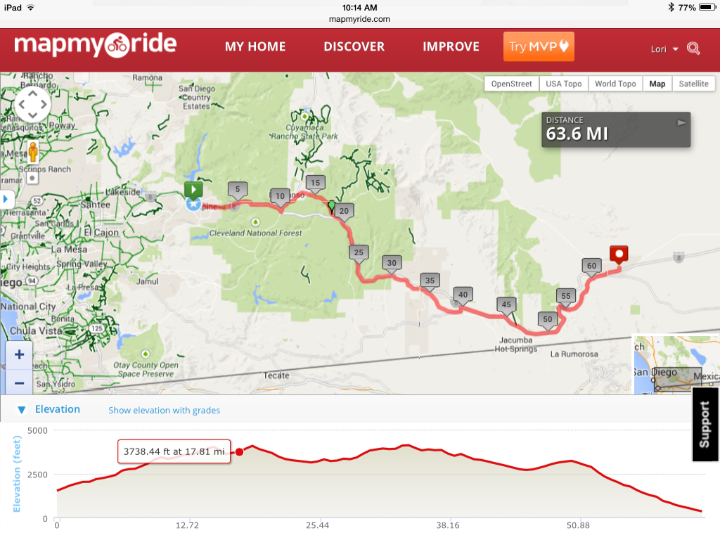
The greatest challenge of this particular stage of my journey was that it was virtually ALL Up Hill! A low but steady grade that went on for what turned out to be about 16 miles. The image below really does not do the challenge justice and skips the first part from Alpine to the intersection with I-8.

As I rode onto I-8 my water supply was running low - down to one 27 oz Klean Kanteen and my 2 liter "head towel drizzling" bottle. Furthermore, there was a disadvantage to being on the interstate: Even though I was legal on this particular section as a cyclist, I would not be legal (technically) as a pedestrian, so I felt compelled to stay on my bicycle the whole time, rather than getting off and pushing as I might have under other circumstances.
Nevertheless, I used the same basic "technique" I have used when walking: pick a point some distance ahead as a goal, and walk/ride to it. Stop. Catch my breath. Take a drink. Start again. This went on for about 3 miles, but it seemed a lot longer, and it was in the wide open. No trees. No shade. Eventually, as a cyclist, I had to pull off at Vista Point, elevation 3000 feet, if only to avoid the "on/off" traffic of vehicles.

My hopes went up just a little as I spotted a brick pedestal in the middle of a similarly walled in viewing area, and yes, it might have been a water fountain at some point in its existence, but had instead become merely an oversized ash try for cigarette butts.
Realizing my water supplies were insufficient to continue, I dug into one of my side panniers to find some card stock and made a sign that read "WATER NEEDED - THANKS!" Just as I was attaching it to the back of my bike, a couple of cars came into the viewing area, a lady stepped out and approached me and I asked her if she had any water she could share with me. In a foreign accent that might have been Eastern European, she told me that she did have a couple of half liter bottles, which she graciously offered to me. These came as a real relief, and I refilled my Klean Kanteens before snapping one last picture and heading back onto the interstate.

I still had about a mile to go to exit at Japatul Valley Road, heading north to Descanso. Still concerned for my water needs, I attached the sign to the side of my bike and had another couple of guys with a truck and trailer offer me more water as we both stopped under the overpass. They informed me that Descanso was only a couple of miles ahead, and mostly downhill, which turned out to be a bit closer than I expected. In spite or my running low on funds, I ended up stopping for a late lunch at the local "Descanso Junction Restaurant". It was nice and cool inside, and I enjoyed my chicken pita pocket sandwhich along with some fries. I also checked my phone which had several messages on it, one from my cousin, and two from Warmshowers hosts further up the road.
The next few miles, off the interstate mostly on HYW 79 and Old HWY 80 were somewhat easier for having more tree cover. I felt comfortable getting off my bicycle and pushing which I did, a lot, in part because a muscle on the inside of my right leg above my knee was starting to cramp up.
There was a moment when I realized I was not really taking in the landscape around me. I was too focused on Just Keepin' On Keepin' On! So, I shifted my perspective a little and realized that off to the side of the road there was a large patch of wild sage. I managed to maneuver my bicycle into a shady spot, prop it up with my newly taped kick-stand, which held (Yeah!) and cut some sage to take with me.

In general, it was just a good idea to keep breathing, and keep enjoying this experience, in spite of the challenges!
A few more miles down the road, as I was riding through Pine Valley, I saw two women walking towards me and one of them took note of my signs reading "The Blue Turtle" outloud. I smiled as they went by, and then stopped and turned, and asked if I could speak with them. I explained that I was in need of shelter for the night, could put up a tent as necessary, but that my climb from Alpine had been particularly difficult and exhausting.
As it turned out, one of the women, Becky, was very open to the idea and asked me to wait for her at a local diner that was closed for the day as she would be walking with her friend for another hour or so. I found the diner, parked my bike and then went searching for a bathroom, ending up at a small mini-mart, and feeling obligated to pay $2.39 for a Cliff Bar since their bathroom facilities were "For Customers Only". (Given I can buy Cliff Bars for $0.99 elsewhere, that was kind of an expensive pit stop!)
Nevertheless, I had an extremely clean bathroom to use, before finding my way back to the diner where I had left my bicycle parked in the shade. I had time to take more notes on my phone messages and do a quick manicure before my host arrived and invited me to follow her a mile or so back to her house. There I met her husband Jack and their dachsund Scooter - the Fifth dachsund/dachsund mix I've met since La Mesa, CA!
And that's where I find myself now, after a somewhat more restful sleep in the coolness of these higher elevations.
It was a hard day. Probably one of the harder ones of my cross-country cycling so far. But it was also rewarding and encouraging given the positive responses I experienced from people, "strangers", all helping me with water, cash, and lodging. As a consequence, I feel encouraged to keep going, and to keep trusting in what I already know to be the mostly generous and peaceful nature of my fellow human beings.
No comments:
Post a Comment